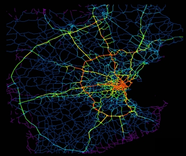
Boston-area roads. Red areas are the biggest sources of drivers. Yellow is next, then green, dark blue, and purple.
Credit: MIT/ Ars Technica
Amazingly, 98% of roads are under capacity in peak periods. Traffic jams are caused when a small number of drivers in key neighborhoods make intensive use of the critical remaining 2% of roads. On these critical roads, problems arise & then ripple outwards across the entire road system.
https://arstechnica.com/information-technology/2013/02/cell-phone-tracking-system-reveals-how-traffic-jams-start/ / Smartphones changed the way we drive going GPS-assisted GPS assisted directions real-time information traffic jams help eliminate traffic jams warning goal study mobile cell phone records data track drivers vehicle movements identify sources of traffic MIT UC-Berkeley UC Berkeley UCB analyzed cell phone records Boston-area commuters call logs towers used to transmit calls researchers trace each individual commute, anonymously from origin destination most detailed maps of urban traffic patterns ever constructed journal Scientific Reports, U.S. Census Bureau travel diaries Boston San Francisco few drivers 98 percent below traffic capacity backups these roads ripple outward, causing traffic to snarl across the Hub drivers from those areas make particularly intensive use of the problematic roads in the system problem neighborhoods might be the key alternatives public transportation carpooling flex time and working from home problem areas /
No comments:
Post a Comment