
Morning glory
Credit: http://viralcamera.com/
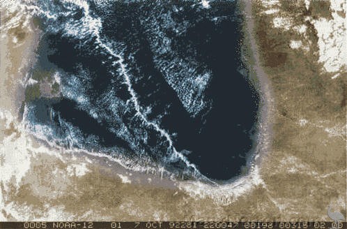
Satellite image
Credit: http://viralcamera.com/
"A Morning Glory cloud is a roll cloud, or arcus cloud, that can be up to 1,000 kilometres (620 miles) long, 1 to 2 kilometres (0.62 to 1.24 miles) high, often only 100 to 200 metres (330 to 660 feet) above the ground. The cloud often travels at the rate of 10 to 20 metres per second. Sometimes there is only one cloud, sometimes there are up to ten consecutive roll clouds." – https://en.wikipedia.org/wiki/Morning_Glory_cloud
Morning Glory clouds have been observed irregularly in a number of places, including central United States, English Channel, Munich, Berlin, eastern Russia, & on one occasion 35km (22 miles) North of Winnipeg, Manitoba, Canada. Those which appear over the southern part of Carpentaria Gulf from from late September to early November are the only ones which appear with any degree of predictability.
Because of the lift generated at the front face of a morning glory cloud, it is popular with glider (sail plane) & hang glider pilots.
/ Morning Glory cloud rare meteorological phenomenon low-level atmospheric solitary wave associated cloud occasionally observed different locations around the world wave often occurs amplitude-ordered series of waves bands of roll clouds southern part Gulf of Carpentaria Northern Australia only known location predicted observed more or less regular basis configuration land sea Morning Glory clouds observed Burketown late September to early November town attracts glider pilots riding phenomenon well formed spectacular clouds Burketown ragged unspectacular cloud lines start to break up only stay well formed over water aircraft significantly better chance sighting the cloud Morning Glory cloud roll cloud arcus cloud up to 1,000 kilometres 620 miles long 1 to 2 kilometres 0.62 to 1.24 miles high often only 100 to 200 metres 330 to 660 feet above ground cloud often travels at rate 10 to 20 metres per second only one cloud sometimes up to ten consecutive roll clouds three distinct types of Morning Glory clouds have been identified Morning Glory often accompanied by sudden wind squalls intense low-level wind shear rapid increase vertical displacement of air parcels sharp pressure jump at the surface cloud continuously formed leading edge eroded trailing edge showers or thunderstorms may develop in its wake front of the cloud strong vertical motion transports air up through the cloud creates rolling appearance air middle and rear cloud becomes turbulent sinks cloud quickly dissipates over land air is drier cloud described solitary wave soliton undular bore wave single crest moves without changing speed or shape world's biggest wave wave may occur without appearance of any clouds exploration unusual cloud formations since ancient times local Garrawa Aboriginal people kangólgi Royal Australian Air Force RAAF pilots first reported phenomenon 1942 Morning Glory cloud Gulf of Carpentaria studied scientists early 1970s mathematical models complex movements air masses in the region Morning Glory cloud not clearly understood rarity rare little significance rainfall or climate complexity atmospheric phenomenon research main causes most Morning Glory occurrences mesoscale circulations sea breezes develop peninsula Cape York Peninsular Gulf of Carpentaria Morning Glories usually associated frontal systems crossing central Australia high pressure northern Australia Morning Glory likely to occur humidity is high provides moisture for cloud form strong sea breezes blown the preceding day conditions that cause the Morning Glory cloud to form in the Gulf of Carpentaria /